Lake Columbia Water Supply Project
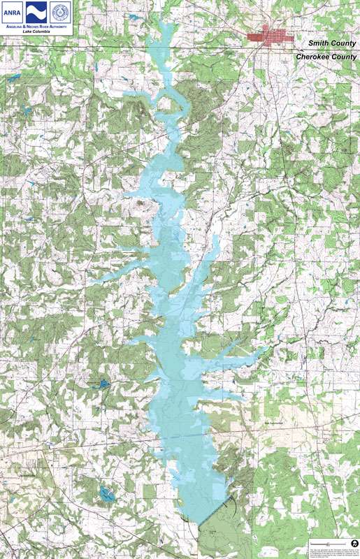
The primary purpose of Lake Columbia is water supply. Lake Columbia is not a flood control reservoir nor is it envisioned to have any hydroelectric capabilities. The lake will be located in the Mud Creek floodplain, with the dam being approximately 5 miles southeast of Jacksonville, Texas. The Lake will primarily lie in Cherokee County, with the northern limits of the lake extending into Smith County (see map at right). It will be 14 miles in length, approximately 1.5 miles wide at its widest point; cover 10,133 acres of land at normal pool. The lake will impound 195,500-acre-feet of water and provide a firm yield of 85,507 acre-feet of water per year to our water supply customers.
Environmental studies indicate that the Lake Columbia site contains no endangered species as currently listed by the U.S. Fish and Wildlife Service. The project will not impact any State designated “ecologically unique stream segments,” nor will it inundate any “priority 1” bottomland hardwood areas identified by the U.S. Fish and Wildlife Service.
Lake Columbia is a recommended water supply strategy in the 2007 State Water Plan and the 2006 Regional Water Plan. These plans recognize the proposed reservoir site as a “unique reservoir site” suitable for the development of a reservoir and legislative confirmation. Senate Bill 1362, approved in 2003, confirmed the unique reservoir site designation and formally changed the name from “Lake Eastex” to “Lake Columbia” in honor of the crew of the space shuttle Columbia.
Key Physical Information for Lake Columbia
| Normal Pool Elevation | 315 ft NGVD (10,133 acres) |
| Fee simple purchase | 318 ft NGVD (11,500 acres) |
| Emergency spillway elevation | 324 ft NGVD |
| 2 year flood elevation | 317.12 ft NGVD |
| 5 year flood elevation | 318.57 ft NGVD |
| 10 year flood elevation | 319.69 ft NGVD |
| 25 year flood elevation | 320.77 ft NGVD |
| 50 year flood elevation | 321.72 ft NGVD |
| 100 year flood elevation | 322.59 ft NGVD |
| 500 year flood elevation | 326.65 ft NGVD |
| Probable maximum flood elevation (Equals 41" of rain in 72 hours) |
334.08 ft NGVD |
| Top of dam | 336 ft NGVD |
| Dam length | 6,800 feet |
| Dam height (from stream bed) |
67 feet |
| Dam footprint | 164 acres |
| Total volume of above-grade fill in dam | 3.6 million cubic yards |
| Reservoir volume at 315 NGVD | 195,500 acre feet |
| Emergency spillway width | 1,100 feet |
| Shoreline length | 94.5 miles |
| Drainage Area | 384 square miles |